
Bugarama topographic map
Interactive map
Click on the map to display elevation.
About this map
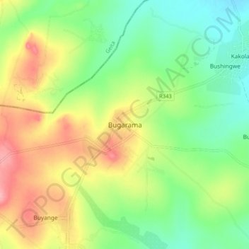
Name: Bugarama topographic map, elevation, terrain.
Location: Bugarama, Msalala, Shinyanga Region, Lake Zone, Tanzania (-3.30665 32.38329 -3.22665 32.46329)
Average elevation: 1,236 m
Minimum elevation: 1,190 m
Maximum elevation: 1,301 m
Other topographic maps
Click on a map to view its topography, its elevation and its terrain.
Mbulu
Mbulu, Kahama Urban, Shinyanga Region, Lake Zone, 37306, Tanzania
Average elevation: 1,211 m