
Belleview topographic map
Click on the map to display elevation.
About this map
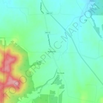
Name: Belleview topographic map, elevation, terrain.
Location: Belleview, Iron County, Missouri, United States (37.66755 -90.76040 37.70755 -90.72040)
Average elevation: 328 m
Minimum elevation: 284 m
Maximum elevation: 449 m
Other topographic maps
Click on a map to view its topography, its elevation and its terrain.
Elephant Rocks State Park
United States > Missouri > Iron County > Graniteville
Average elevation: 374 m