
Thank you for supporting this site ❤️
Make a donation
Make a donation
Nantgarw topographic map
Click on the map to display elevation.
Thank you for supporting this site ❤️
Make a donation
Make a donation
About this map
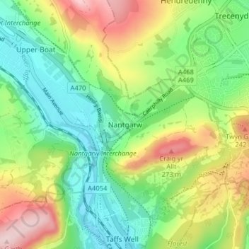
Name: Nantgarw topographic map, elevation, terrain.
Location: Nantgarw, Rhondda Cynon Taf, Wales, CF15 7TU, United Kingdom (51.54207 -3.28374 51.58207 -3.24374)
Average elevation: 132 m
Minimum elevation: 30 m
Maximum elevation: 303 m
Thank you for supporting this site ❤️
Make a donation
Make a donation
Other topographic maps
Click on a map to view its topography, its elevation and its terrain.
Thank you for supporting this site ❤️
Make a donation
Make a donation
Thank you for supporting this site ❤️
Make a donation
Make a donation