
Thank you for supporting this site ❤️
Make a donation
Make a donation
Midlum topographic map
Click on the map to display elevation.
Thank you for supporting this site ❤️
Make a donation
Make a donation
About this map
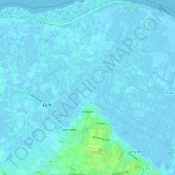
Name: Midlum topographic map, elevation, terrain.
Location: Midlum, Föhr-Amrum, Nordfriesland, Sleeswijk-Holstein, Duitsland (54.69257 8.50356 54.75454 8.54120)
Average elevation: 1 m
Minimum elevation: -3 m
Maximum elevation: 13 m
Thank you for supporting this site ❤️
Make a donation
Make a donation
Other topographic maps
Click on a map to view its topography, its elevation and its terrain.
Westerheide
Duitsland > Sleeswijk-Holstein > Nordfriesland > List auf Sylt > Westerheide
Average elevation: 2 m
Thank you for supporting this site ❤️
Make a donation
Make a donation