
Thank you for supporting this site ❤️
Make a donation
Make a donation
Villers-le-Temple topographic map
Click on the map to display elevation.
Thank you for supporting this site ❤️
Make a donation
Make a donation
About this map
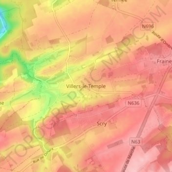
Name: Villers-le-Temple topographic map, elevation, terrain.
Location: Villers-le-Temple, Nandrin, Huy, Liège, Wallonia, 4550, Belgium (50.48811 5.35084 50.52811 5.39084)
Average elevation: 237 m
Minimum elevation: 143 m
Maximum elevation: 279 m
Thank you for supporting this site ❤️
Make a donation
Make a donation
Other topographic maps
Click on a map to view its topography, its elevation and its terrain.
Thank you for supporting this site ❤️
Make a donation
Make a donation
Engis
In late 1930 and early 1931, several thousand cases of acute pulmonary attacks occurred in the Meuse valley, centered on Engis, and 60 people died. A commission of inquiry set up by the Belgian government concluded that the cause was poisonous waste gases, primarily sulfur dioxide, emitted by the many…
Average elevation: 171 m
Thank you for supporting this site ❤️
Make a donation
Make a donation