
Thank you for supporting this site ❤️
Make a donation
Make a donation
Geraldton topographic map
Click on the map to display elevation.
Thank you for supporting this site ❤️
Make a donation
Make a donation
About this map
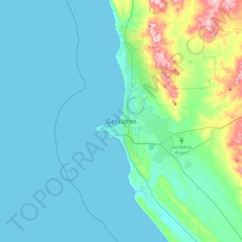
Name: Geraldton topographic map, elevation, terrain.
Average elevation: 33 m
Minimum elevation: -1 m
Maximum elevation: 223 m
Thank you for supporting this site ❤️
Make a donation
Make a donation
Other topographic maps
Click on a map to view its topography, its elevation and its terrain.
Thank you for supporting this site ❤️
Make a donation
Make a donation
Katanning
Australia > Western Australia > Katanning
Katanning railway station has an elevation of 1,024 feet (312 m) above sea level and a rail distance of 225 miles (362 km) from Perth.
Average elevation: 323 m