
Thank you for supporting this site ❤️
Make a donation
Make a donation
Coral Harbour topographic map
Click on the map to display elevation.
Thank you for supporting this site ❤️
Make a donation
Make a donation
About this map
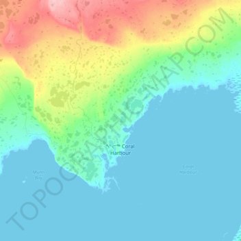
Name: Coral Harbour topographic map, elevation, terrain.
Location: Coral Harbour, Kivalliq Region, Nunavut, X0C 0C0, Canada (64.09718 -83.46359 64.21203 -83.11310)
Average elevation: 24 m
Minimum elevation: 0 m
Maximum elevation: 115 m
Thank you for supporting this site ❤️
Make a donation
Make a donation
Other topographic maps
Click on a map to view its topography, its elevation and its terrain.