
Thank you for supporting this site ❤️
Make a donation
Make a donation
West Dorset topographic map
Click on the map to display elevation.
Thank you for supporting this site ❤️
Make a donation
Make a donation
About this map
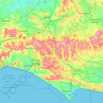
Name: West Dorset topographic map, elevation, terrain.
Location: West Dorset, Dorset, England, United Kingdom (50.59056 -2.96159 50.99965 -2.26145)
Average elevation: 74 m
Minimum elevation: -1 m
Maximum elevation: 276 m
Thank you for supporting this site ❤️
Make a donation
Make a donation
Other topographic maps
Click on a map to view its topography, its elevation and its terrain.
Thank you for supporting this site ❤️
Make a donation
Make a donation
Thank you for supporting this site ❤️
Make a donation
Make a donation