
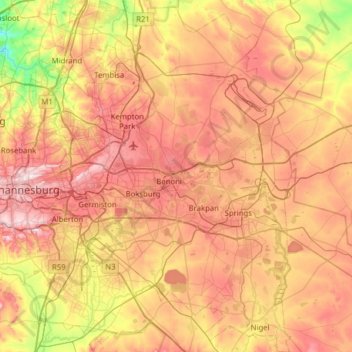
City of Ekurhuleni Metropolitan Municipality topographic map
Interactive map
Click on the map to display elevation.
About this map
Name: City of Ekurhuleni Metropolitan Municipality topographic map, elevation, terrain.
Average elevation: 1,588 m
Minimum elevation: 1,360 m
Maximum elevation: 1,808 m
Ekurhuleni lies on the highveld plateau at about 1600 metres in altitude above sea level (asl). The highest elevation is at the Gillooly's Ridge – Bill Stewart Side – Fisher's Hill at 1772 metres asl. The lowest point is at 1552 metres asl. The city is rich in wetlands, pans, streams and rivers. The city is highly urbanised; however, the north especially has high-potential agricultural land.
Other topographic maps
Click on a map to view its topography, its elevation and its terrain.
City of Johannesburg Metropolitan Municipality
South Africa > Gauteng > City of Johannesburg Metropolitan Municipality
City of Johannesburg Metropolitan Municipality, Gauteng, 2904, South Africa
Average elevation: 1,615 m
Boksburg
South Africa > Gauteng > Boksburg
Boksburg, City of Ekurhuleni Metropolitan Municipality, Gauteng, 1460, South Africa
Average elevation: 1,637 m
City of Johannesburg Metropolitan Municipality
City of Johannesburg Metropolitan Municipality, Gauteng, South Africa
Average elevation: 1,582 m