
Make a donation
Nariño topographic map
Click on the map to display elevation.
Make a donation
Nariño
Nariño has a diverse geography and varied climate according to altitude: hot in the plains of the Pacific and cold in the mountains, where most of the population resides, a situation that is repeated in a north-south direction. Other important cities include Tumaco and Ipiales.
Make a donation
About this map
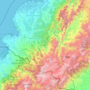
Name: Nariño topographic map, elevation, terrain.
Location: Nariño, RAP Pacífico, Colombia (0.36094 -79.00785 2.68369 -76.83371)
Average elevation: 1,156 m
Minimum elevation: -3 m
Maximum elevation: 4,668 m
Make a donation
Other topographic maps
Click on a map to view its topography, its elevation and its terrain.
Pacho
Pacho is a municipality and town of Colombia in the department of Cundinamarca. Pacho is part of the Rionegro Province and the urban centre is situated at a distance of 88 kilometres (55 mi) from the capital Bogotá at an altitude of 2,136 metres (7,008 ft), while the altitude ranges from 1,000 metres (3,300…
Average elevation: 1,881 m
Tunja
Tunja has a population of 172,548 inhabitants according to the 2018 Census. 0.1% of the city is indigenous, 0.4% is black, and 99.5% is white and Mestizo. It is located in central Colombia, at an elevation ranging from approximately 2,700 metres (8,900 ft) to 2,900 metres (9,500 ft). The city centre is at an…
Average elevation: 2,824 m
Make a donation
Make a donation
Make a donation