
Thank you for supporting this site ❤️
Make a donation
Make a donation
Spitze topographic map
Click on the map to display elevation.
Thank you for supporting this site ❤️
Make a donation
Make a donation
Spitze
Die Topographia Ducatus Montani des Erich Philipp Ploennies aus dem Jahre 1715, Blatt Amt Porz, belegt, dass der Ort bereits 1715 als Ort mit drei Höfen bestand und als a. d. Spitzen bezeichnet wurde.
Thank you for supporting this site ❤️
Make a donation
Make a donation
About this map
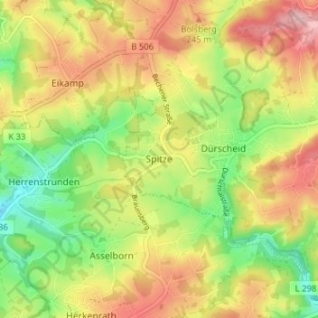
Name: Spitze topographic map, elevation, terrain.
Average elevation: 201 m
Minimum elevation: 123 m
Maximum elevation: 282 m
Thank you for supporting this site ❤️
Make a donation
Make a donation
Other topographic maps
Click on a map to view its topography, its elevation and its terrain.
51515
Deutschland > Nordrhein-Westfalen > Rheinisch-Bergischer Kreis > Kürten > Waldmühle > Kettenberg
Average elevation: 218 m