
Make a donation
Tawang topographic map
Click on the map to display elevation.
Make a donation
Tawang
Tawang district, the basin of Tawang Chu, occupies an area of 2,172 square kilometres (839 sq mi),. The district is roughly located around latitude 27° 45’ N and longitude 90° 15’ E at the northwest extremity of Arunachal Pradesh. Elevations range between 6,000 and 22,000 feet (6,700 m), and inhabitants are found at lower altitude, where they enjoy a cool temperate climate.
Make a donation
About this map
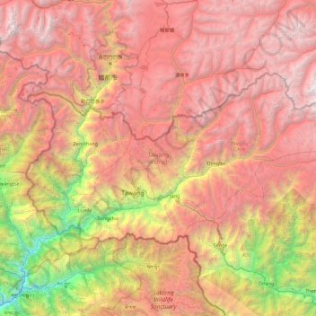
Name: Tawang topographic map, elevation, terrain.
Location: Tawang, Arunachal Pradesh, India (27.45982 91.56231 27.88775 92.45600)
Average elevation: 3,767 m
Minimum elevation: 798 m
Maximum elevation: 6,403 m
Make a donation
Other topographic maps
Click on a map to view its topography, its elevation and its terrain.
Itanagar
India > Arunachal Pradesh > Itanagar EAC
Itanagar is located at 27°06′N 93°37′E / 27.1°N 93.62°E / 27.1; 93.62. It has an average elevation of 320 metres.
Average elevation: 539 m