
Make a donation
Rupnica topographic map
Click on the map to display elevation.
Make a donation
About this map
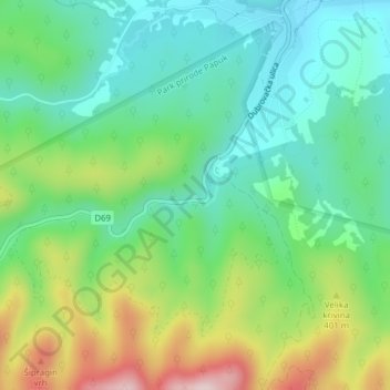
Name: Rupnica topographic map, elevation, terrain.
Average elevation: 325 m
Minimum elevation: 216 m
Maximum elevation: 550 m
Make a donation
Other topographic maps
Click on a map to view its topography, its elevation and its terrain.
Općina Suhopolje
Croatia > Virovitica-Podravina County
It is located on the northern slopes of the Bilogora mountain in the region of Podravina, 10 km southeast of Virovitica; elevation 118 m.
Average elevation: 151 m
Grad Slatina
Croatia > Virovitica-Podravina County
Slatina is a town in the Slavonia region of Croatia. It is located in the Virovitica-Podravina County, at the contact of the Drava valley and the foothills of Papuk mountain, in the central part of the region of Podravina, 29 km (18 mi) southeast of Virovitica; elevation 127 metres (417 feet). It was ruled by…
Average elevation: 137 m
Make a donation
Make a donation