
Thank you for supporting this site ❤️
Make a donation
Make a donation
Palakollu topographic map
Click on the map to display elevation.
Thank you for supporting this site ❤️
Make a donation
Make a donation
Palakollu
At an average altitude of 1.5 metres (4.9 ft), Palakollu town is situated on National Highway 165 (India) and National Highway 216 (India). It is bounded by Krishna district and Vijayawada on the west, Amalapuram and Bay of Bengal on the east, Narasapuram and Bay of Bengal on the south, and Rajahmundry and East Godavari district on the north.
Thank you for supporting this site ❤️
Make a donation
Make a donation
About this map
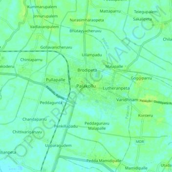
Name: Palakollu topographic map, elevation, terrain.
Average elevation: 7 m
Minimum elevation: 2 m
Maximum elevation: 12 m
Thank you for supporting this site ❤️
Make a donation
Make a donation