
Thank you for supporting this site ❤️
Make a donation
Make a donation
Zetea topographic map
Click on the map to display elevation.
Thank you for supporting this site ❤️
Make a donation
Make a donation
About this map
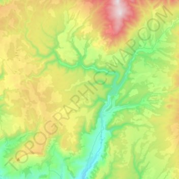
Name: Zetea topographic map, elevation, terrain.
Location: Zetea, Harghita, Romania (46.37382 25.33596 46.56635 25.58163)
Average elevation: 856 m
Minimum elevation: 518 m
Maximum elevation: 1,456 m
Thank you for supporting this site ❤️
Make a donation
Make a donation
Other topographic maps
Click on a map to view its topography, its elevation and its terrain.
Carpathian Mountains
The northwestern Carpathians begin in Slovakia and southern Poland. They surround Transcarpathia and Transylvania in a large semicircle, sweeping towards the southeast, and end on the Danube near Orșova in Romania. The total length of the Carpathians is over 1,500 km (930 mi) and the mountain chain's width…
Average elevation: 980 m