
Thank you for supporting this site ❤️
Make a donation
Make a donation
Tache topographic map
Click on the map to display elevation.
Thank you for supporting this site ❤️
Make a donation
Make a donation
About this map
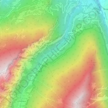
Name: Tache topographic map, elevation, terrain.
Location: Tache, Introd, Valle d'Aosta, 11011, Italia (45.65076 7.15099 45.69076 7.19099)
Average elevation: 1,409 m
Minimum elevation: 746 m
Maximum elevation: 2,195 m
Thank you for supporting this site ❤️
Make a donation
Make a donation