
Beyşehir topographic map
Interactive map
Click on the map to display elevation.
About this map
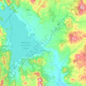
Name: Beyşehir topographic map, elevation, terrain.
Location: Beyşehir, Konya, Central Anatolia Region, Turkey (37.43107 31.27295 38.02078 31.98470)
Average elevation: 1,330 m
Minimum elevation: 1,101 m
Maximum elevation: 2,399 m
Other topographic maps
Click on a map to view its topography, its elevation and its terrain.
Güneşevler Mahallesi
Turkey > Central Anatolia Region > Güneşevler Mahallesi
Güneşevler Mahallesi, Altındağ, Ankara, Central Anatolia Region, Turkey
Average elevation: 900 m
Benzer
Turkey > Central Anatolia Region > Benzer
Benzer, Kaman, Kırşehir, Central Anatolia Region, Turkey
Average elevation: 1,023 m
Basri
Turkey > Central Anatolia Region > Basri
Basri, Polatlı, Ankara, Central Anatolia Region, Turkey
Average elevation: 968 m
Talas
Turkey > Central Anatolia Region
Talas, Kayseri, Central Anatolia Region, Turkey
Average elevation: 1,611 m