
Thank you for supporting this site ❤️
Make a donation
Make a donation
Taneyville topographic map
Click on the map to display elevation.
Thank you for supporting this site ❤️
Make a donation
Make a donation
Taneyville
Taneyville is located in north-central Taney County. The town lies along Missouri Route 76 between Bradleyville and Kissee Mills. The townsite is on a northeast–southwest trending ridge between Swan Creek to the northwest and Beaver Creek to the southeast. The site is at an elevation of 1,073 ft (327 m).
Thank you for supporting this site ❤️
Make a donation
Make a donation
About this map
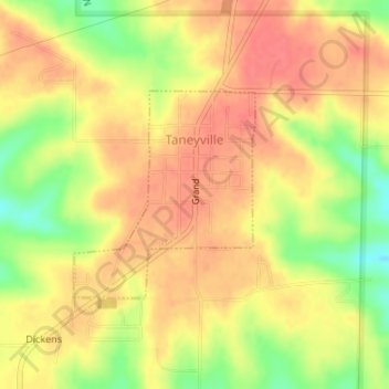
Name: Taneyville topographic map, elevation, terrain.
Location: Taneyville, Taney County, Missouri, 65759, United States (36.73039 -93.04480 36.74482 -93.02906)
Average elevation: 312 m
Minimum elevation: 273 m
Maximum elevation: 333 m
Thank you for supporting this site ❤️
Make a donation
Make a donation
Other topographic maps
Click on a map to view its topography, its elevation and its terrain.
Silver Dollar City's WhiteWater
United States > Missouri > Taney County > Branson
Average elevation: 296 m
Thank you for supporting this site ❤️
Make a donation
Make a donation