
Ōtara-Papatoetoe topographic map
Interactive map
Click on the map to display elevation.
About this map
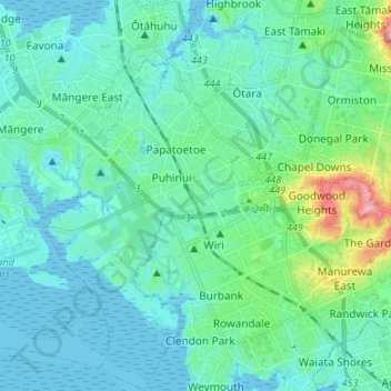
Name: Ōtara-Papatoetoe topographic map, elevation, terrain.
Location: Ōtara-Papatoetoe, Auckland, Nova Zelândia (-37.04550 174.80732 -36.93892 174.90508)
Average elevation: 22 m
Minimum elevation: -1 m
Maximum elevation: 135 m
Other topographic maps
Click on a map to view its topography, its elevation and its terrain.
Clarks Beach
Nova Zelândia > Auckland > Franklin
Clarks Beach, Franklin, Auckland, 2122, Nova Zelândia
Average elevation: 10 m
Upper Harbour
Nova Zelândia > Auckland > Upper Harbour
Upper Harbour, Auckland, Nova Zelândia
Average elevation: 42 m
Hibiscus and Bays
Nova Zelândia > Auckland > Hibiscus and Bays
Hibiscus and Bays, Auckland, Nova Zelândia
Average elevation: 20 m
Great Barrier Island / Aotea
Great Barrier Island / Aotea, Auckland, 0991, Nova Zelândia
Average elevation: 31 m
Auckland
Auckland, Waitematā, Auckland, 1010, Nova Zelândia
Average elevation: 32 m
Waitākere Ranges
Nova Zelândia > Auckland > Waitākere Ranges
Waitākere Ranges, Auckland, Nova Zelândia
Average elevation: 33 m