
Thank you for supporting this site ❤️
Make a donation
Make a donation
Whitburn topographic map
Click on the map to display elevation.
Thank you for supporting this site ❤️
Make a donation
Make a donation
About this map
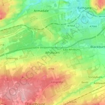
Name: Whitburn topographic map, elevation, terrain.
Location: Whitburn, West Lothian, Scotland, EH47 0QA, United Kingdom (55.82678 -3.72490 55.90678 -3.64490)
Average elevation: 191 m
Minimum elevation: 126 m
Maximum elevation: 282 m
Thank you for supporting this site ❤️
Make a donation
Make a donation
Other topographic maps
Click on a map to view its topography, its elevation and its terrain.
Linlithgow Palace and High Street Conservation Area
United Kingdom > Scotland > West Lothian > Linlithgow
Average elevation: 78 m
Thank you for supporting this site ❤️
Make a donation
Make a donation