
Thank you for supporting this site ❤️
Make a donation
Make a donation
Lumpo topographic map
Click on the map to display elevation.
Thank you for supporting this site ❤️
Make a donation
Make a donation
About this map
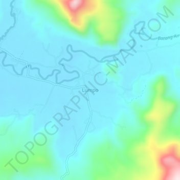
Name: Lumpo topographic map, elevation, terrain.
Location: Lumpo, Pesisir Selatan, West Sumatra, Sumatra, Indonesia (-1.29690 100.56480 -1.25690 100.60480)
Average elevation: 75 m
Minimum elevation: 4 m
Maximum elevation: 434 m
Thank you for supporting this site ❤️
Make a donation
Make a donation
Other topographic maps
Click on a map to view its topography, its elevation and its terrain.