
Thank you for supporting this site ❤️
Make a donation
Make a donation
Proșca topographic map
Click on the map to display elevation.
Thank you for supporting this site ❤️
Make a donation
Make a donation
About this map
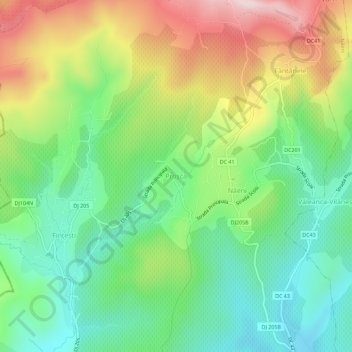
Name: Proșca topographic map, elevation, terrain.
Location: Proșca, Năeni, Buzău, 127393, Romania (45.07484 26.46240 45.11484 26.50240)
Average elevation: 346 m
Minimum elevation: 192 m
Maximum elevation: 597 m
Thank you for supporting this site ❤️
Make a donation
Make a donation
Other topographic maps
Click on a map to view its topography, its elevation and its terrain.
Buzău
The city is located in the center of the county, 100 km north-east of Bucharest, in the South-East of Romania, taking up a total area of 81,3 km2, at the outermost curvature of the Subcarpathian foothills, at the crossroads of the three main Romanian historical provinces: Wallachia, Transylvania and Moldavia.…
Average elevation: 96 m
Thank you for supporting this site ❤️
Make a donation
Make a donation
Thank you for supporting this site ❤️
Make a donation
Make a donation
Thank you for supporting this site ❤️
Make a donation
Make a donation
Thank you for supporting this site ❤️
Make a donation
Make a donation
Thank you for supporting this site ❤️
Make a donation
Make a donation