
Thank you for supporting this site ❤️
Make a donation
Make a donation
Höfen (Enz) topographic map
Click on the map to display elevation.
Thank you for supporting this site ❤️
Make a donation
Make a donation
Höfen (Enz)
Höfen liegt im Enztal im Nordschwarzwald in 360 bis 712 Meter Höhe, unterhalb des Zusammenflusses der Großen Enz und der Kleinen Enz. Die Gemeindefläche ist zu 85 % bewaldet.
Thank you for supporting this site ❤️
Make a donation
Make a donation
About this map
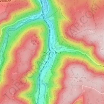
Name: Höfen (Enz) topographic map, elevation, terrain.
Average elevation: 562 m
Minimum elevation: 344 m
Maximum elevation: 716 m
Thank you for supporting this site ❤️
Make a donation
Make a donation