
Thank you for supporting this site ❤️
Make a donation
Make a donation
Blaencwm topographic map
Click on the map to display elevation.
Thank you for supporting this site ❤️
Make a donation
Make a donation
About this map
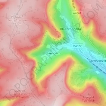
Name: Blaencwm topographic map, elevation, terrain.
Location: Blaencwm, Rhondda Cynon Taf, Wales, CF42 5DT, United Kingdom (51.65727 -3.58284 51.69727 -3.54284)
Average elevation: 409 m
Minimum elevation: 179 m
Maximum elevation: 537 m
Thank you for supporting this site ❤️
Make a donation
Make a donation
Other topographic maps
Click on a map to view its topography, its elevation and its terrain.
Thank you for supporting this site ❤️
Make a donation
Make a donation
Thank you for supporting this site ❤️
Make a donation
Make a donation