
Thank you for supporting this site ❤️
Make a donation
Make a donation
Charleston topographic map
Click on the map to display elevation.
Thank you for supporting this site ❤️
Make a donation
Make a donation
About this map
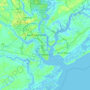
Name: Charleston topographic map, elevation, terrain.
Location: Charleston, Charleston County, South Carolina, United States (32.66851 -80.14385 32.97352 -79.79706)
Average elevation: 4 m
Minimum elevation: -5 m
Maximum elevation: 23 m
Thank you for supporting this site ❤️
Make a donation
Make a donation
Other topographic maps
Click on a map to view its topography, its elevation and its terrain.
Deerwood Heights
United States > South Carolina > Charleston County > North Charleston
Average elevation: 8 m