Geolocate
👉 Easily get elevation data in JSON, GeoTIFF and KML formats using Elevation API
Thank you for supporting this site ❤️
Make a donation

Barlow topographic map

Click on the map to display elevation.

👉 Easily get elevation data in JSON, GeoTIFF and KML formats using Elevation API
Thank you for supporting this site ❤️
Make a donation

About this map

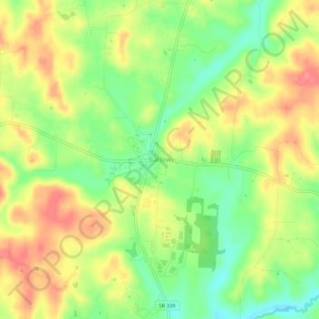
Name: Barlow topographic map, elevation, terrain.

Location: Barlow, Washington County, Ohio, 45712, United States (39.37869 -81.68485 39.41869 -81.64485)

Average elevation: 242 m

Minimum elevation: 203 m

Maximum elevation: 279 m

Other topographic maps

Click on a map to view its topography, its elevation and its terrain.

Marietta

United States > Ohio > Washington County

Average elevation: 215 m

Belpre

United States > Ohio > Washington County

Average elevation: 206 m

Devola

United States > Ohio > Washington County

Average elevation: 218 m

Lowell

United States > Ohio > Washington County

Average elevation: 222 m

Duck Creek

United States > Ohio > Washington County > Marietta

Average elevation: 242 m

Wesley Township

United States > Ohio > Washington County

Average elevation: 259 m

Beverly

United States > Ohio > Washington County

Average elevation: 215 m

Beverly

United States > Ohio > Washington County

Average elevation: 215 m

Marietta

United States > Ohio > Washington County

Average elevation: 215 m

Duck Creek

United States > Ohio > Washington County > Marietta

Average elevation: 242 m