
Make a donation
Brno topographic map
Click on the map to display elevation.
Make a donation
Brno
Under the Köppen climate classification, Brno has an oceanic climate (Cfb) for −3 °C original isoterm, but near of the (−2.5 °C average temperature in January, month most cold) or include by updated classification in humid continental climate (Dfb) with cold winters and warm to hot summers. However, in the last 20 years the temperature has increased, and summer days with temperature above 30 °C (86 °F) are quite common. The average temperature is 9.4 °C (49 °F), the average annual precipitation is about 505 mm (19.88 in), the average number of precipitation days is 150, the average annual sunshine is 1,771 hours, and the prevailing wind direction is northwest. The weather box below shows average data between 1961 and 1990. Its elevation above sea level varies from 190 m (623 ft) to 497 m (1,631 ft). The highest peak in the municipal area is the Kopeček Hill (479 m; 1,572 ft), and the highest point overall lies in Útěchov on the border with the municipality of Vranov.
Make a donation
About this map
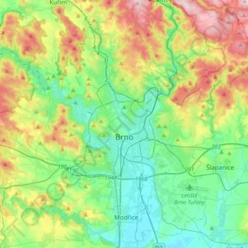
Name: Brno topographic map, elevation, terrain.
Average elevation: 296 m
Minimum elevation: 186 m
Maximum elevation: 531 m
Make a donation
Other topographic maps
Click on a map to view its topography, its elevation and its terrain.