
Thank you for supporting this site ❤️
Make a donation
Make a donation
Sutton at Hone topographic map
Click on the map to display elevation.
Thank you for supporting this site ❤️
Make a donation
Make a donation
About this map
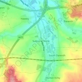
Name: Sutton at Hone topographic map, elevation, terrain.
Location: Sutton at Hone, Dartford, Kent, England, DA4 9ET, United Kingdom (51.39098 0.21539 51.43098 0.25539)
Average elevation: 44 m
Minimum elevation: 7 m
Maximum elevation: 109 m
Thank you for supporting this site ❤️
Make a donation
Make a donation
Other topographic maps
Click on a map to view its topography, its elevation and its terrain.