
Thank you for supporting this site ❤️
Make a donation
Make a donation
Frenet topographic map
Click on the map to display elevation.
Thank you for supporting this site ❤️
Make a donation
Make a donation
About this map
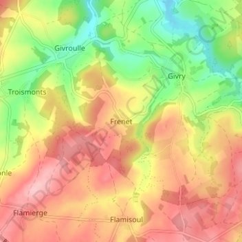
Name: Frenet topographic map, elevation, terrain.
Location: Frenet, Bertogne, Bastogne, Luxembourg, Wallonie, 6686, Belgique (50.02884 5.60790 50.06884 5.64790)
Average elevation: 437 m
Minimum elevation: 357 m
Maximum elevation: 504 m
Thank you for supporting this site ❤️
Make a donation
Make a donation
Other topographic maps
Click on a map to view its topography, its elevation and its terrain.
Thank you for supporting this site ❤️
Make a donation
Make a donation
Thank you for supporting this site ❤️
Make a donation
Make a donation
Thank you for supporting this site ❤️
Make a donation
Make a donation