
Thank you for supporting this site ❤️
Make a donation
Make a donation
Mananga River topographic map
Click on the map to display elevation.
Thank you for supporting this site ❤️
Make a donation
Make a donation
About this map
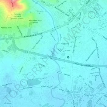
Name: Mananga River topographic map, elevation, terrain.
Location: Mananga River, Talisay, Cebu, Central Visayas, Philippines (10.24302 123.83169 10.26632 123.83717)
Average elevation: 17 m
Minimum elevation: -1 m
Maximum elevation: 111 m
Thank you for supporting this site ❤️
Make a donation
Make a donation
Other topographic maps
Click on a map to view its topography, its elevation and its terrain.
Thank you for supporting this site ❤️
Make a donation
Make a donation
Thank you for supporting this site ❤️
Make a donation
Make a donation