
Al-Najaf District topographic map
Interactive map
Click on the map to display elevation.
About this map
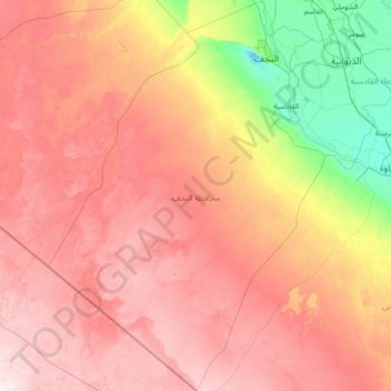
Name: Al-Najaf District topographic map, elevation, terrain.
Location: Al-Najaf District, Al-Najaf Governorate, Iraq (29.87260 42.70575 32.36197 44.76863)
Average elevation: 237 m
Minimum elevation: 9 m
Maximum elevation: 514 m
Other topographic maps
Click on a map to view its topography, its elevation and its terrain.
حي الشرطة
حي الشرطة, Al-Najaf Central Subdistrict, Al-Najaf District, Al-Najaf Governorate, Iraq
Average elevation: 46 m
Al-Shabaka
Al-Shabaka, Al-Shabaka Subdistrict, Al-Najaf District, Al-Najaf Governorate, Iraq
Average elevation: 295 m
Al-Najaf
Al-Najaf, Al-Najaf Central Subdistrict, Al-Najaf District, Al-Najaf Governorate, 54001, Iraq
Average elevation: 30 m