
Thank you for supporting this site ❤️
Make a donation
Make a donation
Playa Grande topographic map
Click on the map to display elevation.
Thank you for supporting this site ❤️
Make a donation
Make a donation
About this map
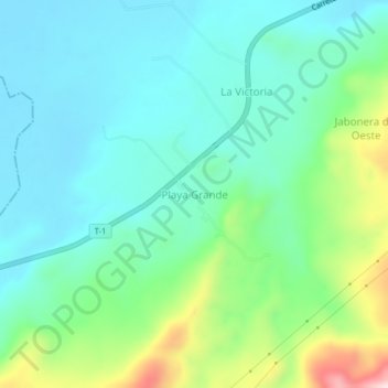
Name: Playa Grande topographic map, elevation, terrain.
Average elevation: 115 m
Minimum elevation: 25 m
Maximum elevation: 388 m
Thank you for supporting this site ❤️
Make a donation
Make a donation
Other topographic maps
Click on a map to view its topography, its elevation and its terrain.
Parroquia Independencia
Venezuela > Estado Mérida > Municipio Tulio Febres Cordero
Average elevation: 10 m