
Thank you for supporting this site ❤️
Make a donation
Make a donation
San Jerónimo topographic map
Click on the map to display elevation.
Thank you for supporting this site ❤️
Make a donation
Make a donation
About this map
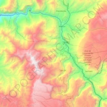
Name: San Jerónimo topographic map, elevation, terrain.
Location: San Jerónimo, Luya, Amazonas, Perú (-6.10439 -78.17363 -5.90256 -77.93742)
Average elevation: 2,064 m
Minimum elevation: 677 m
Maximum elevation: 3,593 m
Thank you for supporting this site ❤️
Make a donation
Make a donation
Other topographic maps
Click on a map to view its topography, its elevation and its terrain.