
Thank you for supporting this site ❤️
Make a donation
Make a donation
Valdarena topographic map
Click on the map to display elevation.
Thank you for supporting this site ❤️
Make a donation
Make a donation
About this map
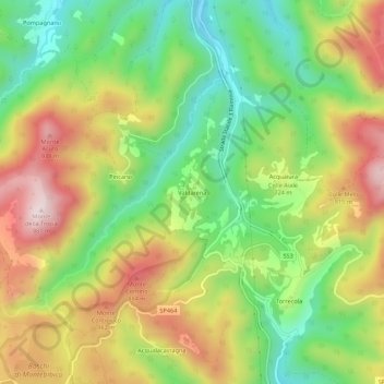
Name: Valdarena topographic map, elevation, terrain.
Location: Valdarena, Spoleto, Perugia, Umbria, 06049, Italia (42.65323 12.70151 42.69323 12.74151)
Average elevation: 688 m
Minimum elevation: 459 m
Maximum elevation: 969 m
Thank you for supporting this site ❤️
Make a donation
Make a donation
Other topographic maps
Click on a map to view its topography, its elevation and its terrain.