Geolocate

Mohácsi kistérség topographic map

Interactive map

Click on the map to display elevation.

About this map

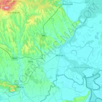
Name: Mohácsi kistérség topographic map, elevation, terrain.

Location: Mohácsi kistérség, Baranya megye, Transdanubio Meridional, Transdanubia, Hungría (45.81071 18.37008 46.20922 18.86875)

Average elevation: 134 m

Minimum elevation: 79 m

Maximum elevation: 665 m

Other topographic maps

Click on a map to view its topography, its elevation and its terrain.

XXI. kerület

Hungría > Budapest

XXI. kerület, Budapest, Hungría Central, Hungría

Average elevation: 110 m

Vecsés

Hungría > Vecsés

Vecsés, Vecsési járás, Pest megye, Hungría Central, 2220, Hungría

Average elevation: 122 m

Danubio

Hungría > Budapest

Danubio, Budapest, Hungría Central, 1036, Hungría

Average elevation: 114 m

Baranya megye

Hungría

Baranya megye, Transdanubio Meridional, Transdanubia, Hungría

Average elevation: 147 m

Baranya megye

Hungría

Mohácsi járás, Baranya megye, Transdanubio Meridional, Hungría

Average elevation: 119 m

Hédervár

Hungría > Hédervár > Hédervár

Hédervár, Mosonmagyaróvári járás, Győr-Moson-Sopron megye, Transdanubio Occidental, Transdanubia, 9178, Hungría

Average elevation: 116 m

Csősz

Hungría > Csősz

Csősz, Székesfehérvári járás, Fejér megye, Transdanubio Central, Transdanubia, 8122, Hungría

Average elevation: 121 m