
Thank you for supporting this site ❤️
Make a donation
Make a donation
Waldmünchen topographic map
Click on the map to display elevation.
Thank you for supporting this site ❤️
Make a donation
Make a donation
About this map
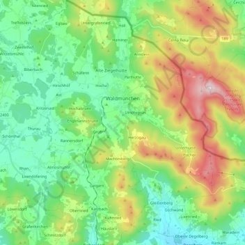
Name: Waldmünchen topographic map, elevation, terrain.
Location: Waldmünchen, Landkreis Cham, Beieren, 93449, Duitsland (49.29171 12.61014 49.43480 12.78637)
Average elevation: 590 m
Minimum elevation: 385 m
Maximum elevation: 1,035 m
Thank you for supporting this site ❤️
Make a donation
Make a donation
Other topographic maps
Click on a map to view its topography, its elevation and its terrain.