
Thank you for supporting this site ❤️
Make a donation
Make a donation
Crescent Spur topographic map
Click on the map to display elevation.
Thank you for supporting this site ❤️
Make a donation
Make a donation
About this map
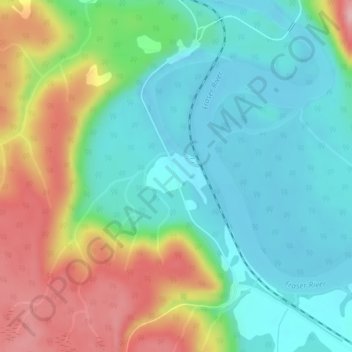
Name: Crescent Spur topographic map, elevation, terrain.
Average elevation: 703 m
Minimum elevation: 645 m
Maximum elevation: 815 m
Thank you for supporting this site ❤️
Make a donation
Make a donation
Other topographic maps
Click on a map to view its topography, its elevation and its terrain.
Kettle Lakes
Canada > British Columbia > Regional District of Fraser-Fort George > Area H (Robson Valley/Canoe)
Average elevation: 1,189 m