
Thank you for supporting this site ❤️
Make a donation
Make a donation
Ciorani topographic map
Click on the map to display elevation.
Thank you for supporting this site ❤️
Make a donation
Make a donation
About this map
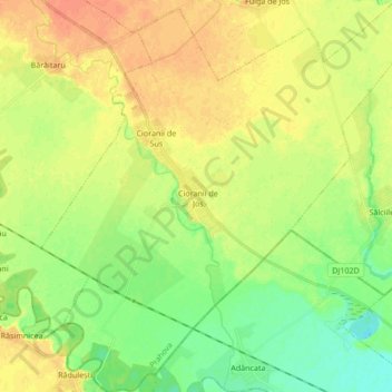
Name: Ciorani topographic map, elevation, terrain.
Location: Ciorani, Prahova, Romania (44.76105 26.34475 44.88156 26.50931)
Average elevation: 75 m
Minimum elevation: 57 m
Maximum elevation: 91 m
Thank you for supporting this site ❤️
Make a donation
Make a donation
Other topographic maps
Click on a map to view its topography, its elevation and its terrain.
Sinaia
Sinaia is about 65 kilometres (40 miles) northwest of Ploiești and 48 kilometres (30 miles) south of Brașov, in a mountainous area on the Prahova River valley, just east of the Bucegi Mountains. The town's altitude varies between 767 to 860 metres (2,516 to 2,822 feet) above sea level.
Average elevation: 1,098 m
Thank you for supporting this site ❤️
Make a donation
Make a donation