
Thank you for supporting this site ❤️
Make a donation
Make a donation
Thompson Township topographic map
Click on the map to display elevation.
Thank you for supporting this site ❤️
Make a donation
Make a donation
About this map
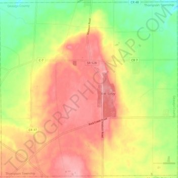
Name: Thompson Township topographic map, elevation, terrain.
Location: Thompson Township, Geauga County, Ohio, 44086, United States (41.64142 -81.10244 41.71479 -81.00268)
Average elevation: 347 m
Minimum elevation: 282 m
Maximum elevation: 401 m
Thank you for supporting this site ❤️
Make a donation
Make a donation
Other topographic maps
Click on a map to view its topography, its elevation and its terrain.