
Thank you for supporting this site ❤️
Make a donation
Make a donation
Palmerton topographic map
Click on the map to display elevation.
Thank you for supporting this site ❤️
Make a donation
Make a donation
Palmerton
The borough is located 3 miles (5 km) east of Bowmanstown and 5 miles (8 km) north of the twin towns of Walnutport and Slatington, 7 miles (11 km) southeast of Lehighton, and 58 miles (93 km) south of the city of Scranton. Palmerton's elevation is 407 feet (124 m) above sea level.
Thank you for supporting this site ❤️
Make a donation
Make a donation
About this map
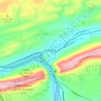
Name: Palmerton topographic map, elevation, terrain.
Location: Palmerton, Carbon County, Pennsylvania, United States (40.78919 -75.65770 40.81354 -75.57711)
Average elevation: 230 m
Minimum elevation: 108 m
Maximum elevation: 470 m
Thank you for supporting this site ❤️
Make a donation
Make a donation
Other topographic maps
Click on a map to view its topography, its elevation and its terrain.
Albrightsville
United States > Pennsylvania > Carbon County > Kidder Township
Average elevation: 498 m