
Pruszków County topographic map
Interactive map
Click on the map to display elevation.
About this map
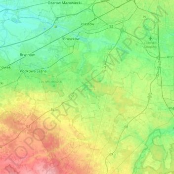
Name: Pruszków County topographic map, elevation, terrain.
Location: Pruszków County, Masovian Voivodeship, Poland (52.00058 20.63080 52.20118 20.98904)
Average elevation: 116 m
Minimum elevation: 84 m
Maximum elevation: 177 m
Other topographic maps
Click on a map to view its topography, its elevation and its terrain.
Mińsk County
Mińsk County, Masovian Voivodeship, Poland
Average elevation: 143 m
Radom County
Radom County, Masovian Voivodeship, Poland
Average elevation: 179 m
Radom
Poland > Masovian Voivodeship > Radom
Radom, Masovian Voivodeship, Poland
Average elevation: 168 m
Praga-Południe
Poland > Masovian Voivodeship > Warsaw
Praga-Południe, Warsaw, Warszawa, Masovian Voivodeship, Poland
Average elevation: 86 m
Sokołów
Poland > Masovian Voivodeship > Sokołów
Sokołów, gmina Gostynin, powiat gostyniński, Masovian Voivodeship, 09-500, Poland
Average elevation: 122 m
Warsaw
Poland > Masovian Voivodeship > Warsaw
Warsaw, Masovian Voivodeship, Poland
Average elevation: 96 m