
Thank you for supporting this site ❤️
Make a donation
Make a donation
Bristow Point topographic map
Click on the map to display elevation.
Thank you for supporting this site ❤️
Make a donation
Make a donation
About this map
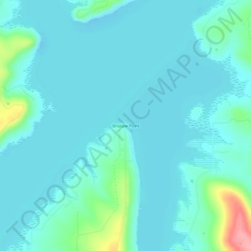
Name: Bristow Point topographic map, elevation, terrain.
Location: Bristow Point, Pittsburg County, Oklahoma, United States (35.10176 -95.63249 35.14176 -95.59249)
Average elevation: 190 m
Minimum elevation: 173 m
Maximum elevation: 287 m
Thank you for supporting this site ❤️
Make a donation
Make a donation
Other topographic maps
Click on a map to view its topography, its elevation and its terrain.