
Thank you for supporting this site ❤️
Make a donation
Make a donation
Staythorpe CP topographic map
Click on the map to display elevation.
Thank you for supporting this site ❤️
Make a donation
Make a donation
Staythorpe CP
The land is very low-lying and level, varying little in elevation between 12–14 metres (39–46 ft) throughout.
Thank you for supporting this site ❤️
Make a donation
Make a donation
About this map
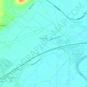
Name: Staythorpe CP topographic map, elevation, terrain.
Average elevation: 16 m
Minimum elevation: 9 m
Maximum elevation: 58 m
Thank you for supporting this site ❤️
Make a donation
Make a donation
Other topographic maps
Click on a map to view its topography, its elevation and its terrain.
Newark on Trent
United Kingdom > England > Nottinghamshire > Newark and Sherwood
Average elevation: 18 m