
Payerne topographic map
Interactive map
Click on the map to display elevation.
About this map
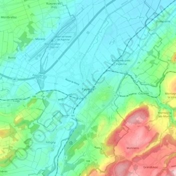
Name: Payerne topographic map, elevation, terrain.
Location: Payerne, District de la Broye-Vully, Waadland, Zwitserland (46.78085 6.90488 46.86162 6.96662)
Average elevation: 495 m
Minimum elevation: 436 m
Maximum elevation: 677 m
Other topographic maps
Click on a map to view its topography, its elevation and its terrain.
Sassel
Zwitserland > Waadland > District de la Broye-Vully > Valbroye
Sassel, Valbroye, District de la Broye-Vully, Waadland, 1534, Zwitserland
Average elevation: 610 m
Le Moulin
Zwitserland > Waadland > District de la Broye-Vully > Cudrefin
Le Moulin, Cudrefin, District de la Broye-Vully, Waadland, 1588, Zwitserland
Average elevation: 469 m