
Thank you for supporting this site ❤️
Make a donation
Make a donation
Mostaganem topographic map
Click on the map to display elevation.
Thank you for supporting this site ❤️
Make a donation
Make a donation
About this map
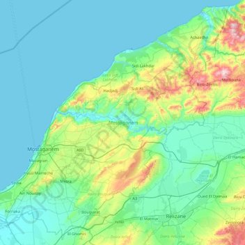
Name: Mostaganem topographic map, elevation, terrain.
Location: Mostaganem, Algeria (35.67164 -0.11565 36.33403 0.74082)
Average elevation: 122 m
Minimum elevation: -1 m
Maximum elevation: 769 m
Thank you for supporting this site ❤️
Make a donation
Make a donation
Other topographic maps
Click on a map to view its topography, its elevation and its terrain.