
Thank you for supporting this site ❤️
Make a donation
Make a donation
Rollinsford topographic map
Click on the map to display elevation.
Thank you for supporting this site ❤️
Make a donation
Make a donation
About this map
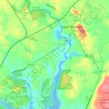
Name: Rollinsford topographic map, elevation, terrain.
Average elevation: 32 m
Minimum elevation: -9 m
Maximum elevation: 90 m
Thank you for supporting this site ❤️
Make a donation
Make a donation
Other topographic maps
Click on a map to view its topography, its elevation and its terrain.
Center Strafford
United States > New Hampshire > Strafford County > Strafford
Average elevation: 148 m
New Durham Corner
United States > New Hampshire > Strafford County > New Durham
Average elevation: 184 m
Thank you for supporting this site ❤️
Make a donation
Make a donation
Thank you for supporting this site ❤️
Make a donation
Make a donation