
Unterkulm topographic map
Interactive map
Click on the map to display elevation.
About this map
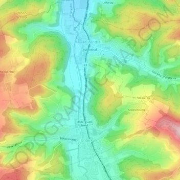
Name: Unterkulm topographic map, elevation, terrain.
Location: Unterkulm, Bezirk Kulm, Argovie, 5726, Suisse (47.30232 8.08209 47.33851 8.13216)
Average elevation: 534 m
Minimum elevation: 433 m
Maximum elevation: 688 m
Other topographic maps
Click on a map to view its topography, its elevation and its terrain.
Schlossrued
Suisse > Argovie > Bezirk Kulm
Schlossrued, Bezirk Kulm, Argovie, 5044, Suisse
Average elevation: 576 m
Menziken
Suisse > Argovie > Bezirk Kulm
Menziken, Bezirk Kulm, Argovie, 5737, Suisse
Average elevation: 625 m