
Thank you for supporting this site ❤️
Make a donation
Make a donation
Dodge City topographic map
Click on the map to display elevation.
Thank you for supporting this site ❤️
Make a donation
Make a donation
Dodge City
The elevation is 628 feet (191 m) above sea level.
Thank you for supporting this site ❤️
Make a donation
Make a donation
About this map
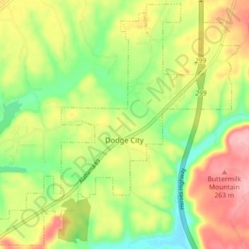
Name: Dodge City topographic map, elevation, terrain.
Location: Dodge City, Cullman County, Alabama, United States (34.01853 -86.91942 34.06929 -86.85655)
Average elevation: 192 m
Minimum elevation: 127 m
Maximum elevation: 267 m
Thank you for supporting this site ❤️
Make a donation
Make a donation
Other topographic maps
Click on a map to view its topography, its elevation and its terrain.
Thank you for supporting this site ❤️
Make a donation
Make a donation
Thank you for supporting this site ❤️
Make a donation
Make a donation
Thank you for supporting this site ❤️
Make a donation
Make a donation