Geolocate

金沙江 - Jīnshā Jiāng topographic map

Interactive map

Click on the map to display elevation.

About this map

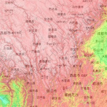
Name: 金沙江 - Jīnshā Jiāng topographic map, elevation, terrain.

Location: 金沙江 - Jīnshā Jiāng, སྨི་ལི་རང་སྐྱོང་རྫོང / 木里藏族自治县 / Muli, Prefectura autónoma yi de Liangshan, Sichuan, 617000, China (25.96172 97.24388 32.97748 104.63496)

Average elevation: 3,186 m

Minimum elevation: 187 m

Maximum elevation: 6,574 m

Other topographic maps

Click on a map to view its topography, its elevation and its terrain.

永富乡

China > Sichuan > 永富乡

永富乡, 宝兴县 / Baoxing, 雅安市 / Ya'an, Sichuan, China

Average elevation: 2,155 m

嘉陵江

China > Sichuan

嘉陵江, 高坪区 / Gaoping, 南充市 / Nanchong, Sichuan, 400000, China

Average elevation: 516 m

华蓥市

China > Sichuan > 华蓥市

华蓥市, 华蓥市 / Huaying, 广安市 / Guang'an, Sichuan, China

Average elevation: 444 m