
Thank you for supporting this site ❤️
Make a donation
Make a donation
Treasure Island topographic map
Click on the map to display elevation.
Thank you for supporting this site ❤️
Make a donation
Make a donation
Treasure Island
With an elevation of only three feet, the Great Gale of 1848 carved out John's Pass on the island's north end and split off two smaller islands, called the Isle of Palms and Isle of Capri.
Thank you for supporting this site ❤️
Make a donation
Make a donation
About this map
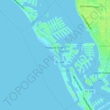
Name: Treasure Island topographic map, elevation, terrain.
Location: Treasure Island, Pinellas County, Florida, United States (27.73403 -82.79093 27.79570 -82.75252)
Average elevation: 2 m
Minimum elevation: -2 m
Maximum elevation: 14 m
Thank you for supporting this site ❤️
Make a donation
Make a donation
Other topographic maps
Click on a map to view its topography, its elevation and its terrain.
Thank you for supporting this site ❤️
Make a donation
Make a donation
Thank you for supporting this site ❤️
Make a donation
Make a donation
Thank you for supporting this site ❤️
Make a donation
Make a donation